Move up one level.
BEST took place during 1992 and 1993 in the South Atlantic Ocean. This document describes data from the BEST current meter array.
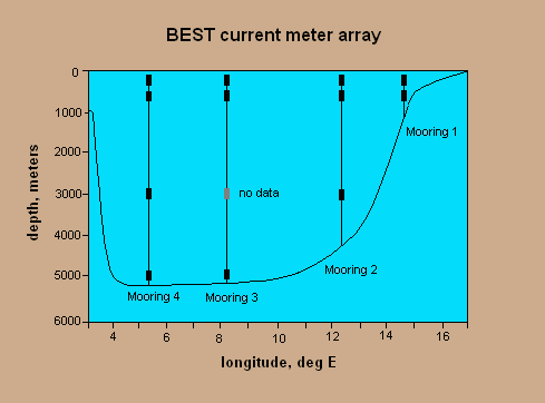
The figure below shows the current meter array as a vertical section along 30 deg S. To reach a particular current meter, click on its representation in the figure. This will take you to a page of metadata relevant to that instrument, plus descriptive data plots from it.
The BEST project was designed to shed light on the transport and variablility of the Benguela Current, with particular attention to the ratio of Agulhas Current and South Atlantic Current water masses within the Benguela Current. The experiment involved hydrographic surveys, inverted echo sounders, pressure gauges, and a moored array of current meters (the subject of this data report) - as well as analysis of the TOPEX/POSEIDON satellite altimeter data.
BEST objectives contributed to the WOCE international plan; the current meter array has been identified by WOCE as component ACM-4.
The experiment's PIs were A.L.Gordon and S.L.Garzoli of the Lamont-Doherty Earth Observatory, and R.D.Pillsbury of Oregon State University. Gordon and Garzoli conducted the hydrographic surveys. The echo sounders were operated by Garzoli, and the current meters by Pillsbury.
The positions of the current meters and echo sounders are shown in a map of the region.
Measurements were made and instruments serviced during three cruises:
The instruments (current meters and echo sounders) were deployed during the BEST 1 cruise and recovered during BEST 3. The four current meter moorings were positioned along 30 deg S in the broad channel between the African continent and Walvis Ridge. Each mooring carried a current meter at a depth of about 200 m and another at 500 m. Three of the moorings had instruments at 3000 m and the two deepest moorings had current meters at about 5000 m.
All of the current meters were Aanderaa RCM8 meters. Data return was good with two exceptions: (a) the speed sensor of the shallow instrument at Mooring 2 failed after about 2 weeks; and (b) the 3000 m instrument at Mooring 3 stopped recording as soon as it entered the water.
Acknowledgements
Funds for the BEST current meter work were provided via Grant OCE-9116922 from the National Science Foundation Physical Oceanography Program, which is gratefully acknowledged. We appreciate the assistance and cooperation given by the masters and crews of the R/V Africana and R/V Maurice Ewing, and by our seagoing colleagues and companions on the deployment and recovery cruises.
Return to top of page.
The moorings were instrumented with Aanderaa RCM-8 current meters to record speed, direction, and temperature, with some meters equipped to record pressure. All of the instruments employed Savonius rotors and the large RCM-5 vane, however.
The current meter recording interval was set to 60 minutes. During the 60-minute interval the number of rotor revolutions and compass directions were sampled 50 times. Each such sample represents a current vector, its magnitude given by the rotor revolutions and its direction by the compass reading. In the RCM-8 on-board circuitry resolves the vector into two components, eastward and northward. Successive components are added and immedidately stored. When the selected recording interval has elapsed, the resulting average vector magnitude and average angle are calculated and recorded as speed and direction.
Temperature and pressure are instantaneous measurements at the end of the sampling interval.
The current meter stores analogs in the range [0, 1023], rather than the actual speeds, temperatures, etc. In the case of the BEST data the analogs were converted to usable form (speeds in cm/sec, temperatures in degrees, etc.) by means of calibration equations supplied by the OSU Buoy Group's calibration facility. Speeds were calculated by means of a nonlinear equation obtained with the Group's tow tank. The threshold of the Savonius rotor is 1.86 cm/sec. Speeds below the threshold (i.e., analog values of 0) were set to half the threshold, 0.93 cm/sec.
Each current record is archived in three forms: the raw data, exactly as recorded by the instrument, processed data in which the analog values have been cleaned up and converted to metric units, and llp filtered data. The llp (low low passed) file is made from the processed file; it has a time increment of 6 hours and is produced with a 60+1+60 point Cosine-Lanczos filter with half-amplitude at 40 hours and half-power at 46.6 hours. This filter removes the diurnal tides and all higher frequencies.
Occasional problems appear in the data as isolated spikes, gaps, or short runs of unexplainably erratic values. Problem areas only a few data cycles in length are corrected by linear interpolation. Those longer than a few hours but shorter than a week are bridged by predictive interpolation. The latter technique employs Anderson's (1974) algorithm for a predictive filter that utilizes the data on both sides of the gap (Smylie et al, 1973; Ulrych et al, 1973). All corrections to the data are noted elsewhere on this disk.
References for predictive interpolation
Anderson, N. 1974. On the calculation of filter coefficients for maximum entropy spectral analysis. Geophysics 39,69-72.Smylie, D.E., G.K.C. Clarke and T.J. Ulrych. 1973. Analysis of irregularities in the earth's rotation. Methods in Computational Phys. 13, 391-430.
Ulrych, T.J., D.E. Smylie, O.G. Jensen and G.K.C. Clarke. 1973. Predictive filtering and smoothing of short records by using maximum entropy. J. Geophys. Res. 78, 4959-4964.
Return to top of page.
To see all of the time series recorded at a particular mooring, click on the name of the mooring below. The moorings lie in a line along 30 deg S; Mooring 1 is at the eastern end of the line (nearest the African continent) and Mooring 4 is at the west end of the line.
Return to top of page.