ICM3 took place during 1995, 96, and 97 in the western Indian Ocean. These web pages describe data from the ICM3 current meter array.
Contents:
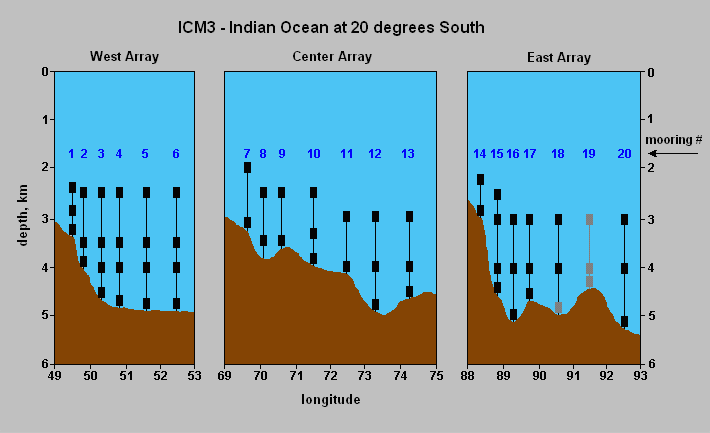
A schematic of the mooring array is shown below as a vertical section along 20 deg S. To reach a particular current meter, click on its representation in the figure. This will take you to a page of metadata relevant to that instrument, plus descriptive data plots from it.
From here you can move up one level to the list of data reports.
The ICM3 array was designed to aid the development of a description of the water characteristics, velocity structure and transport of the three systems of deep western boundary currents in the Indian Ocean. The boundary currents carry water of Antarctic origin northward into the three major basins of the Indian Ocean. Knowledge of their transports will provide direct information about the overturning rate of the Indian Ocean.
The three components of ICM3 span the western portions of the Mascarene Basin (West Array), the Central Indian Basin (Central Array) and the West Australian Basin (East Array) from a nominal depth of about 2500 m to 100 m off the bottom. The moorings were deployed between 5 May and 1 June, 1995 on the WOCE Hydrographic Programme line I3 conducted by R/V Knorr. They were recovered between 16 January and 6 February from the R/V Melville.
Click here to return to the beginning of the ICM3 data report.
Twenty moorings were instrumented with Aanderaa RCM-8 current meters to record speed, direction, and temperature, with some meters equipped to record pressure. All of the instruments employed Savonius rotors and the large RCM5-style vanes.
The current meter recording interval was set to 30 minutes. During the 30-minute interval the number of rotor revolutions and compass directions were sampled 50 times. Each such sample represents a current vector, its magnitude given by the rotor revolutions and its direction by the compass reading. In the RCM-8 on-board circuitry resolves the vector into two components, eastward and northward. Successive components are added and immedidately stored. When the selected recording interval has elapsed, the resulting average vector magnitude and average angle are calculated and recorded as speed and direction.
Temperature and pressure are instantaneous measurements at the end of the sampling interval.
The current meter stores analogs in the range [0, 1023], rather than the actual speeds, temperatures, etc. In the case of the ICM3 data the analogs were converted to usable form (speeds in cm/sec, temperatures in degrees, etc.) by means of calibration equations supplied by the OSU Buoy Group's calibration facility. Speeds were calculated by means of a nonlinear equation obtained with the Group's tow tank. The threshold of the Savonius rotor is 1.86 cm/sec. Speeds below the threshold (i.e., analog values of 0) were set to half the threshold - 0.93 cm/sec.
Each current record is archived in three forms: the raw data, exactly as recorded by the instrument, processed data in which the analog values have been cleaned up and converted to metric units, and llp filtered data. The llp (low low passed) file is made from the processed file; it has a time increment of 6 hours and is produced with a 60+1+60 point Cosine-Lanczos filter with half-amplitude at 40 hours and half-power at 46.6 hours. This filter removes the diurnal tides and all higher frequencies.
Occasional problems appear in the data as isolated spikes, gaps, or short runs of unexplainably erratic values. Problem areas only a few data cycles in length are corrected by linear interpolation. Those longer than a few hours but shorter than a week are bridged by predictive interpolation. The latter technique employs Anderson's (1974) algorithm for a predictive filter that utilizes the data on both sides of the gap (Smylie et al, 1973; Ulrych et al, 1973). All corrections to the data are noted elsewhere on this disk.
References for predictive filtering
Anderson, N. 1974. On the calculation of filter coefficients for maximum entropy spectral analysis. Geophysics 39,69-72.
Smylie, D.E., G.K.C. Clarke and T.J. Ulrych. 1973. Analysis of irregularities in the earth's rotation. Methods in Computational Phys. 13, 391-430.
Ulrych, T.J., D.E. Smylie, O.G. Jensen and G.K.C. Clarke. 1973. Predictive filtering and smoothing of short records by using maximum entropy. J. Geophys. Res. 78, 4959-4964.
Return to the beginning of the ICM3 data report.
To see all of the time series recorded at a particular mooring, click on the name of the mooring below. The moorings lie along a line extending eastward from Madagascar. Mooring 1 is at the west end of the line (nearest Madagascar) and Mooring 20 is at the east end of the line near the Ninety East Ridge.
Return to the beginning of the ICM3 data report.